Alaska!
Warning: Brew a pot of coffee and put the kids to bed before you start reading this because it's a looooong one!
Hello everyone!
Well, we went on our Alaska trip last week and the week before. Cathy took lots of photos with her new fancy camera. So let's get to it!
Here I am struggling to stand up. Do you think I packed enough stuff?

After driving up on Sunday and spending the night at a motel, we caught our morning flight out of Portland and flew nonstop to Anchorage. Cathy's sister Christy was waiting for us at theTed Stevens Anchorage Airport along with her fluffy dog, Kodi. Kodi was all excited because there was a nearby P-A-R-K (he goes apeshit if you say the word "park," so you have to spell it if you want him to stay calm, although he's pretty much figured out how to spell it, too). When we got there, not only were there other dogs at the P-A-R-K, but there were also four moose. We had been on the ground in Alaska for no more than 30 minutes and we were already seeing "mooses" (meese?):

The P-A-R-K also had a lot of mushrooms, which was unexpected but in hindsight makes sense. Here's a great big Fly Amanita:
 Later, we dropped off our luggage and then headed out for a drive. Here is the Little Soo River. If you look closely, you can see one of the ferocious, nasty mosquitoes that rule the Alaska skies for a few months each year:

Further up the valley, we could see some cool crags in the distance:

I included this photo just to keep me humble:

This is overlooking the Little Soo valley:

Sunset on top of the world:

Tuesday
We headed east up the Matanuska River toward the Matanuska Glacier. Here's the river:

The river is pretty silty because it's fed by the glacier. As the glacier slowly moves down its valley, it scours the rocks below and the rock debris and dust gets caught in the ice. Eventually, the ice reaches the end of the glacier and melts. A lot of the rock dust just ends up in a pile, but some of it ends up as silt in the river. I guess my community college geology classes weren't completely useless after all.

This is Bonnie Lake. I'd be just fine with Cathy and I spending the rest of our lives in a cabin there:

Here's the glacier:

This photo gives a better view of the deposited "rock dust":

Enough geology. How about a pretty rainbow?

Here are a bunch of Sockeye salmon, or as they are called in Alaska, Red salmon. At first I didn't understand why so many were dead, but then I realized that this was their spawning grounds. They go through all the trouble of swimming upstream for hundreds of miles to lay their eggs and then they die. The eggs hatch and the young fish eventually make it out to the ocean (although some spend their whole lives in freshwater lakes) if they don't get eaten along the way. Then about 5 or 6 years later once those fish have grown up (at least the females), they swim all the way back upstream and lay eggs right near where they originally hatched. Which is why it's so important to protect them--if they don't make it back, they don't lay their eggs, and if they don't lay their eggs, all the salmon will be gone in that river before too long. But they're doing just fine in Alaska:

Enough with the Forest Biology! What is this: Rob Nye the Science Guy?
Wednesday
This marks the start of the big four day North Slope trip.
Early on we stopped at a lake in Willow where the Iditarod sled dog race currently "officially" starts. It used to start about 30 miles to the south in Wasilla, home of my sister-in-law and Tina Fey, but those liberal Democrat environmentalists somehow made it snow less (no doubt so they could blame it on global warming and try to destroy the economy), and as a result the race had to be moved to the north. I think the Democrats overtaxed the clouds to the point where they could no longer afford to produce snow. Or maybe this is all just God's way of punishing us for allowing gay marriage in two states. That's probably what it is.
Anyway, it still gets cold enough for the lake to freeze over in the winter. So the race starts here, heads across the frozen lake, and then goes another 1,000 miles or so to the west until hitting the Bering Sea. If you look closely, you might be able to see a narrow trail cut between the trees about 1/3 of the way over from the left, and this is the trail:

Some more scenery:

Since it was essentially autumn in Alaska, there was a surprising amount of colors to be seen:


Before long, we came across a place called, "Skinny Dick's Halfway Inn." From what I heard, there's supposed to be some sort of sexual innuendo in the name, but I just don't get it. It must be too subtle for me...

Near there we pulled over and saw what may or may not be Denali/McKinley in the distance:

Later, we stopped by an interpretive center at the Trans Alaska Pipeline outside Fairbanks:

The pipeline had a warning sign for your safety. It's good to know that there are signs to protect people who were born without brains. This one informs us that if we climb on the pipeline, we could fall and get hurt. Yes, gravity works near the pipeline, too.
Then the sign has a few words about emergencies. I know this because it says, "A FEW WORDS ABOUT EMERGENCIES," all in capital letters.
Let's take a closer look at these few words:
Maybe they need to add a few more words about emergencies.
The sign then goes on to basically say that you shouldn't light a cigarette if a couple thousand gallons of flammable crude oil comes spraying toward you. It then finishes by again reminding everyone to stay off the pipeline just in case anybody forgot after reading all those other words.
The cynic in me realizes that this sign has nothing to do with anyone caring about the safety of tourists. It's all about keeping that oil nice and safe on its way to Valdez.
Now that I've blathered on and on about the sign, here's a photo of it:

Those silver-colored things sticking up in the next photo are cooling fins. I guess the crude oil is heated up so it flows better, and the legs that hold the pipeline off the ground tend to get hot and melt the snow and ice or permafrost, which makes it less stable. The cooling fins dissipate the heat from the oil to keep the legs closer to the ground temperature. Who said my blog isn't educational?

Apparently, this is some sort of device they used to send through the pipeline every so often to clean out the gunk that builds up over time. According to a different sign, they use a more modern version these days:

We then spent the night in Squarebanks.
Thursday
The next morning, we got up at 3:30 am (ugh) and were on the road by 4:30.
A couple hours later, we made it to the start of the legendary Dalton Highway! It was named after James Dalton who apparently was an engineer who, well, just click on the highway link if you need to know who James Dalton was. But unless you're an engineer or a Rush fan, you probably don't care.
The locals call the highway "The Haul Road," and I think that's more appropriate since it resembles a rural back road more than a "highway." It's used to get supplies to and from Alaska's North Slope, where a whole bunch of oil-drilling goes on. And that's where we were headed!
The road is supposed to be all dangerous and scary. It probably is in January. But it was pretty tame for us. Did I mention that it's 666 km long? Scary!

Here is the road snaking through some rolling hills:

Later that morning we crossed the Yukon River (more about the river on the way back):

In the photo below you can see me in the back seat filming with my new video camera. Once I figure out how to edit all the footage into a comprehensive, watchable production, I'll post it here in Rob Dow's World (once I figure out how to upload video).

Just after crossing the bridge, there is a turnout where we could drive under the pipeline. There was also a restaurant (one of only a handful on the 400+ mile road) that we visited, and we ended up having one of the best breakfasts we'd ever had. Who knew?

A girl and her dog...

The road and the pipeline:

This is called "Finger Rock." We stopped here to stretch our legs and take some photos and next thing I knew, a tour bus stopped and about five dozen elderly people with cameras slowly exited the bus. Many of them for some strange reason figured that I was interested in chatting with them. I didn't come to Alaska to talk with strange old people! They asked me idiotic questions such as, "How about that view?" It's bad enough that I'm expected to help them cross the street, but now I have to help them look at the view? I don't know, maybe they thought I was one of their grandsons or something. If that wasn't bad enough, one of them actually took a picture of us as Christy was using one of the gas cans to refill the tank. Being around tourists is bad enough, but being the subject of their interest is just too much for me. You better pay me if you want to take my picture, you old hag!
I just pretended that this rock was nature's way of giving the finger to the tourists every time they snapped a photo of it:

One of the funnest names on the trip was this place, Gobblers Knob:

Here's the view from atop "The Knob":

More scenery...

Here's a sign for the "farthest north spruce tree" complete with a sign that helpfully says, "DO NOT CUT." Unfortunately, some assclown either could not read or fancied himself some sort of outlaw and tried to cut it down. To further illustrate what a loser this guy must have been, he couldn't even cut it all the way--just enough to kill the tree. So now there's a dead tree behind the sign.
Incidentally, just a few dozen yards away from the road and to the left of this photo stood a living, thriving spruce tree--slightly to the north of the "farthest north spruce tree." But it's not right next to the road.

Atigun Pass is the big, exciting pass along the road that crosses the Brooks Range. These photos don't quite do it justice:

It's not the highest pass I've ever crossed, nor is it the steepest or longest. But it is pretty high, steep, and long, and the road is just a narrow strip dug into the side of a pretty unstable-looking mountain:

After the pass, the road flattens out and parallels a river. Notice the lack of trees. This is tundra, baby!

It might be hard to tell from the photo, but that's fog in the distance:


No, these are not the Painted Hills in the Badlands in South Dakota, but just some hills on the Alaskan North Slope:

Getting dirtier...

Here are some muskoxen, and they sure are weird looking creatures. Though, I'm sure they'd say the same about me...

Eventually, we made it to Deadhorse (charming name, eh?) and then Prudhoe Bay, where we spent the night.
Friday
This was "home sweet home" for us the night before: The Arctic Caribou Inn. Initially, we were going to stay at an old work camp, but when we got there, there was some guy sleeping in our room (the doors don't lock, either) and nobody working who could kick the guy out. True story.

In the morning we drove around and took pictures of all the crazy oil equipment. I won't pretend to know what any of them do.
Here's some sort of drilling rig thingy:

It's a strange feeling to drive for hours and hours and see almost nothing but nature, and then all of a sudden see sights like this:

Here's some sort of oil-related building for doing something that has to do with the extraction or transportation of petroleum--what, I don't know. But I do understand that the flame is to burn off excess natural gas, supposedly.

Here's where Cathy's sister works. She runs the whole place. From what I understand, they maintain the oil wells on the slope. The window in the middle of the photo with the big sliding doors immediately to the right is her office. The building to the left houses the cafeteria and the rooms where the employees stay when they're working up there:

Notice the wide tires on this machine. The driver has a lever that can raise or lower the tire pressure to help it cross different types of terrain. Update: I've been informed that this machine is called a "Rollagon.":

A picture is worth a thousand words. Here's the "Prudhoe Bay National Forest" (the five wooden trees under the Halliburton sign):

Before too long, we headed south again. This slope in the road isn't very long, but it's pretty steep. If you look at the guardrail, you can see where it's been smashed up repeatedly by semi trucks bouncing off it like pinballs during the icy winter months:

If you click on this next photo and look closely, you can see a small herd of Dall Sheep in the bottom left corner:

Here's a shot of a caribou. Apparently, the females (cows) have antlers, too, and they shed their "velvet" in the fall and the rest of the antlers in the spring. Because of this, they can bully around the males (who lose their antlers in the fall) and keep the best feeding spots to themselves in the winter when food is scarce. This works out well since odds are they're knocked up and could really use that extra food. Anyway, the ones we saw were losing their velvet, and it was somewhat bloody and pretty disgusting to look at:

The wide open road...


If you look closely, you can see the guardrail along the edge of the road heading down the south side of Atigun Pass:

The road, the pipeline, and the river:


Here's a turnout that marks the Arctic Circle. To the north of here it stays light 24 hours a day during the summer solstice and dark 24 hours a day on the winter solstice:

I like this side of the sign much better:

Here is the Yukon River bridge again from a different angle:
 It's the third-longest river in the US, and this is the only bridge that crosses it in the whole state:

Here's some more scenery:

Back at the beginning of the highway, and Kodi is wondering why everyone is out of the truck except him:

Remember those red gas cans?

Back on the main highway with another hour or so to go before we stay in Fairbanks again, here's a shot of the sunset:

Saturday
We started the day by stopping by an espresso stand to pick up some morning joe, and our coffee came in cups with hand-drawn pictures on them. Either Kim makes her "1s" look like "2s," or she has a pretty low opinion of me:

We decided to take a different route from Fairbanks to Wasilla. Along the way, we stopped to take a photo of what may or may not be Denali/McKinley. It probably isn't:

Next we stopped by a place with burl wood animal sculptures and the most interesting sign I've seen in a while:

A typical Alaska mosquito:

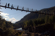
Further down the road we came across a suspension bridge for a segment of the pipeline:

Here's another moose.

Still more scenery...

Hey, I can see Russia from here! Or at least I can see a sign with Russian writing on it:

There's no shortage of beautiful, tall mountains in Alaska. I'm pretty sure this is not Denali/McKinley:

Another glacier:

Our next stop was the town of Paxson, population 43. I hear the mayor is being considered as a choice for Secretary of State in the McCain administration. Anyway, some wise ass apparently decided to have a little fun with a reader board sign at the sole gas station in town. I swear I didn't do it!

Some interesting clouds:

We took the Denali Highway westward.


This is one of the most amazing vistas I've ever seen. The photo doesn't even come close to reproducing what it was like in person. Cathy pointed out that we could see for miles and miles, but there wasn't a single sign of humans--no houses, utility lines, nothing. Notice the mountain peak on the left above the cloud:

Here's that same viewpoint but facing a different direction:

We made it home pretty late and pretty exhausted, but that drive was totally worth it.
Sunday
Sunday was the big day for the charter flight up to Denali! We drove up to Talkeetna airport that afternoon.
Here's our ride:

Click on any of these photos for a larger view:


 This glacier is over 45 miles long and is the largest in Denali National Park:


Notice the airplane on this glacier? That's because it's not only a glacier but also a landing strip! And we're about to land!

Here's that plane (and one more behind it) from atop the glacier:

Words can't accurately describe the view. The photo doesn't quite do it justice, either:


The Coyle Seesters:

We didn't get to see much of Denali/McKinley because it was fogged in. But who gives a crap? Not us.
The second Monday
If that weren't enough, the next day we headed to see more glaciers, this time southeast of Anchorage. Here's a big chunk of ice floating inTurnagain Arm Portage Lake near Porter Portage:

The chunk came fromPorter Portage Glacier:

Next, we headed to the town of Whittier to catch a glacier cruise. The only way to get there by car is to drive through a long tunnel that actually used to be just for trains (or take a ridiculously long ferry around the Kenai Peninsula). Now, it's a combination railroad-highway tunnel. From what I could tell, it works like this: the floor of the tunnel is set up with both rails and a drivable surface much like a railroad crossing for the whole length. The tunnel opens up to car traffic every half hour or so for about ten minutes in one direction. Next, trains (if there are any) are allowed to go through. Then traffic heading in the other direction gets to go, followed by more trains (if any). The drive through is a bit bumpy, but then you end up with cool photos like this:

On to the cruise! We headed out into the Prince William Sound. It was pretty foggy and rainy the whole time, so we didn't get to see as many glaciers as we could have on a clear day. But we did see a few:

Here's another. The chunks of ice are from "calving," which is just geology speak for "chunks of ice falling off into the water." We were hoping to see some big chunks fall, but we only saw (relatively) small ones. Still, it was interesting to hear the floating ice chunks banging and scraping the boat. The captain and the crew weren't concerned, so neither were we.

Here's a shot of us trying to stay warm and dry:

Here are some Harbor Seals, including one that appears to be as fascinated with the boat full of camera-toting tourists as they are with him (or her):

I just like this photo:

On the way back, we wrapped up our trip the way we started it--seeing a moose:


Fortunately, Sarah Palin was out of the state campaigning, otherwise she probably would have shot it by now.
Tuesday
We spent the next day recovering and flew out on a red-eye to Portland that evening.
All in all it was a thoroughly eventful trip that I'll most definitely remember for the rest of my life. I would have blogged about it earlier, but I honestly needed a few days to let it all soak in. There was so much that we saw that was just incredible and reminded me how insignificant we are in the grand scheme of things. And I spent enough time in Wasilla that I think I'm ready to lead the free world.
Speaking of which, there's a new Palin on the block. Vote (Michael) Palin for President!
Anyway, I'm off to Sandpoint, Idaho for a few days to go paint my parent's house and hopefully do some kayaking and biking.
Rob
Hello everyone!
Well, we went on our Alaska trip last week and the week before. Cathy took lots of photos with her new fancy camera. So let's get to it!
Here I am struggling to stand up. Do you think I packed enough stuff?

Monday
After driving up on Sunday and spending the night at a motel, we caught our morning flight out of Portland and flew nonstop to Anchorage. Cathy's sister Christy was waiting for us at the

The P-A-R-K also had a lot of mushrooms, which was unexpected but in hindsight makes sense. Here's a great big Fly Amanita:
 Later, we dropped off our luggage and then headed out for a drive. Here is the Little Soo River. If you look closely, you can see one of the ferocious, nasty mosquitoes that rule the Alaska skies for a few months each year:
Further up the valley, we could see some cool crags in the distance:

I included this photo just to keep me humble:

This is overlooking the Little Soo valley:

Sunset on top of the world:

Tuesday
We headed east up the Matanuska River toward the Matanuska Glacier. Here's the river:

The river is pretty silty because it's fed by the glacier. As the glacier slowly moves down its valley, it scours the rocks below and the rock debris and dust gets caught in the ice. Eventually, the ice reaches the end of the glacier and melts. A lot of the rock dust just ends up in a pile, but some of it ends up as silt in the river. I guess my community college geology classes weren't completely useless after all.

This is Bonnie Lake. I'd be just fine with Cathy and I spending the rest of our lives in a cabin there:

Here's the glacier:

This photo gives a better view of the deposited "rock dust":

Enough geology. How about a pretty rainbow?

Here are a bunch of Sockeye salmon, or as they are called in Alaska, Red salmon. At first I didn't understand why so many were dead, but then I realized that this was their spawning grounds. They go through all the trouble of swimming upstream for hundreds of miles to lay their eggs and then they die. The eggs hatch and the young fish eventually make it out to the ocean (although some spend their whole lives in freshwater lakes) if they don't get eaten along the way. Then about 5 or 6 years later once those fish have grown up (at least the females), they swim all the way back upstream and lay eggs right near where they originally hatched. Which is why it's so important to protect them--if they don't make it back, they don't lay their eggs, and if they don't lay their eggs, all the salmon will be gone in that river before too long. But they're doing just fine in Alaska:

Enough with the Forest Biology! What is this: Rob Nye the Science Guy?
Wednesday
This marks the start of the big four day North Slope trip.
Early on we stopped at a lake in Willow where the Iditarod sled dog race currently "officially" starts. It used to start about 30 miles to the south in Wasilla, home of my sister-in-law and Tina Fey, but those liberal Democrat environmentalists somehow made it snow less (no doubt so they could blame it on global warming and try to destroy the economy), and as a result the race had to be moved to the north. I think the Democrats overtaxed the clouds to the point where they could no longer afford to produce snow. Or maybe this is all just God's way of punishing us for allowing gay marriage in two states. That's probably what it is.
Anyway, it still gets cold enough for the lake to freeze over in the winter. So the race starts here, heads across the frozen lake, and then goes another 1,000 miles or so to the west until hitting the Bering Sea. If you look closely, you might be able to see a narrow trail cut between the trees about 1/3 of the way over from the left, and this is the trail:

Some more scenery:

Since it was essentially autumn in Alaska, there was a surprising amount of colors to be seen:


Before long, we came across a place called, "Skinny Dick's Halfway Inn." From what I heard, there's supposed to be some sort of sexual innuendo in the name, but I just don't get it. It must be too subtle for me...

Near there we pulled over and saw what may or may not be Denali/McKinley in the distance:

Later, we stopped by an interpretive center at the Trans Alaska Pipeline outside Fairbanks:

The pipeline had a warning sign for your safety. It's good to know that there are signs to protect people who were born without brains. This one informs us that if we climb on the pipeline, we could fall and get hurt. Yes, gravity works near the pipeline, too.
Then the sign has a few words about emergencies. I know this because it says, "A FEW WORDS ABOUT EMERGENCIES," all in capital letters.
Let's take a closer look at these few words:
The Trans Alaska Pipeline was designed and constructed to the highest standards to safely and efficiently transport crude oil for our country's energy needs.And China's, too.
Nevertheless, emergencies may occur.Translation: They may occur, but it's not our fault, so don't even think of suing.
Indications of such an emergency might include:You can tell they're serious because they're back to using ALL CAPITAL LETTERS! And it's a good thing they've explained that crude oil is black. I only know what crude oil looks like from the Beverly Hillbillies intro. Sure it was black, but the show was in black and white, so it could have really been purple for all I knew.
- THE PRESENCE ON THE GROUND OF CRUDE OIL, A HEAVY BLACK SUBSTANCE
You mean it's not normal for oil to randomly shoot out of the pipeline?
- A BLACK SPRAY ABOVE THE PIPELINE OR COMING FROM THE GROUND
Does a "hissing or roaring sound or liquid escaping under pressure" sound uniquely different than other hissing or roaring sounds? What about the hissing sound of a King Cobra and the roaring sound of an African Lion as they simultaneously try to bite my leg and neck, respectively, moments after escaping from a traveling circus? Is that not an emergency unless it sounds like "liquid escaping under pressure?"
- A HISSING OR ROARING SOUND OF LIQUID ESCAPING UNDER PRESSURE
Maybe they need to add a few more words about emergencies.
Insert your own fart joke here...
- A STRONG PUNGENT ODOR
Or here...
- A WHITE CLOUD OF STEAM OR FOG
More fart jokes...
- A PATCH OF DEAD OR DISCOLORED VEGETATION
This fart joke just writes itself!
- FLAMES
If you should become aware of a pipeline emergency: LEAVE THE AREA IMMEDIATELY!Clearly this is really, really important because not only is it in all caps, but it's also both italicized and underlined! That's like super-duper high priority! Pay attention, people!
The sign then goes on to basically say that you shouldn't light a cigarette if a couple thousand gallons of flammable crude oil comes spraying toward you. It then finishes by again reminding everyone to stay off the pipeline just in case anybody forgot after reading all those other words.
The cynic in me realizes that this sign has nothing to do with anyone caring about the safety of tourists. It's all about keeping that oil nice and safe on its way to Valdez.
Now that I've blathered on and on about the sign, here's a photo of it:

Those silver-colored things sticking up in the next photo are cooling fins. I guess the crude oil is heated up so it flows better, and the legs that hold the pipeline off the ground tend to get hot and melt the snow and ice or permafrost, which makes it less stable. The cooling fins dissipate the heat from the oil to keep the legs closer to the ground temperature. Who said my blog isn't educational?

Apparently, this is some sort of device they used to send through the pipeline every so often to clean out the gunk that builds up over time. According to a different sign, they use a more modern version these days:

We then spent the night in Squarebanks.
Thursday
The next morning, we got up at 3:30 am (ugh) and were on the road by 4:30.
A couple hours later, we made it to the start of the legendary Dalton Highway! It was named after James Dalton who apparently was an engineer who, well, just click on the highway link if you need to know who James Dalton was. But unless you're an engineer or a Rush fan, you probably don't care.
The locals call the highway "The Haul Road," and I think that's more appropriate since it resembles a rural back road more than a "highway." It's used to get supplies to and from Alaska's North Slope, where a whole bunch of oil-drilling goes on. And that's where we were headed!
The road is supposed to be all dangerous and scary. It probably is in January. But it was pretty tame for us. Did I mention that it's 666 km long? Scary!

Here is the road snaking through some rolling hills:

Later that morning we crossed the Yukon River (more about the river on the way back):

In the photo below you can see me in the back seat filming with my new video camera. Once I figure out how to edit all the footage into a comprehensive, watchable production, I'll post it here in Rob Dow's World (once I figure out how to upload video).

Just after crossing the bridge, there is a turnout where we could drive under the pipeline. There was also a restaurant (one of only a handful on the 400+ mile road) that we visited, and we ended up having one of the best breakfasts we'd ever had. Who knew?

A girl and her dog...

The road and the pipeline:

This is called "Finger Rock." We stopped here to stretch our legs and take some photos and next thing I knew, a tour bus stopped and about five dozen elderly people with cameras slowly exited the bus. Many of them for some strange reason figured that I was interested in chatting with them. I didn't come to Alaska to talk with strange old people! They asked me idiotic questions such as, "How about that view?" It's bad enough that I'm expected to help them cross the street, but now I have to help them look at the view? I don't know, maybe they thought I was one of their grandsons or something. If that wasn't bad enough, one of them actually took a picture of us as Christy was using one of the gas cans to refill the tank. Being around tourists is bad enough, but being the subject of their interest is just too much for me. You better pay me if you want to take my picture, you old hag!
I just pretended that this rock was nature's way of giving the finger to the tourists every time they snapped a photo of it:

One of the funnest names on the trip was this place, Gobblers Knob:

Here's the view from atop "The Knob":

More scenery...

Here's a sign for the "farthest north spruce tree" complete with a sign that helpfully says, "DO NOT CUT." Unfortunately, some assclown either could not read or fancied himself some sort of outlaw and tried to cut it down. To further illustrate what a loser this guy must have been, he couldn't even cut it all the way--just enough to kill the tree. So now there's a dead tree behind the sign.
Incidentally, just a few dozen yards away from the road and to the left of this photo stood a living, thriving spruce tree--slightly to the north of the "farthest north spruce tree." But it's not right next to the road.

Atigun Pass is the big, exciting pass along the road that crosses the Brooks Range. These photos don't quite do it justice:

It's not the highest pass I've ever crossed, nor is it the steepest or longest. But it is pretty high, steep, and long, and the road is just a narrow strip dug into the side of a pretty unstable-looking mountain:

After the pass, the road flattens out and parallels a river. Notice the lack of trees. This is tundra, baby!

It might be hard to tell from the photo, but that's fog in the distance:


No, these are not the Painted Hills in the Badlands in South Dakota, but just some hills on the Alaskan North Slope:

Getting dirtier...

Here are some muskoxen, and they sure are weird looking creatures. Though, I'm sure they'd say the same about me...

Eventually, we made it to Deadhorse (charming name, eh?) and then Prudhoe Bay, where we spent the night.
Friday
This was "home sweet home" for us the night before: The Arctic Caribou Inn. Initially, we were going to stay at an old work camp, but when we got there, there was some guy sleeping in our room (the doors don't lock, either) and nobody working who could kick the guy out. True story.

In the morning we drove around and took pictures of all the crazy oil equipment. I won't pretend to know what any of them do.
Here's some sort of drilling rig thingy:

It's a strange feeling to drive for hours and hours and see almost nothing but nature, and then all of a sudden see sights like this:

Here's some sort of oil-related building for doing something that has to do with the extraction or transportation of petroleum--what, I don't know. But I do understand that the flame is to burn off excess natural gas, supposedly.

Here's where Cathy's sister works. She runs the whole place. From what I understand, they maintain the oil wells on the slope. The window in the middle of the photo with the big sliding doors immediately to the right is her office. The building to the left houses the cafeteria and the rooms where the employees stay when they're working up there:

Notice the wide tires on this machine. The driver has a lever that can raise or lower the tire pressure to help it cross different types of terrain. Update: I've been informed that this machine is called a "Rollagon.":

A picture is worth a thousand words. Here's the "Prudhoe Bay National Forest" (the five wooden trees under the Halliburton sign):

Before too long, we headed south again. This slope in the road isn't very long, but it's pretty steep. If you look at the guardrail, you can see where it's been smashed up repeatedly by semi trucks bouncing off it like pinballs during the icy winter months:

If you click on this next photo and look closely, you can see a small herd of Dall Sheep in the bottom left corner:

Here's a shot of a caribou. Apparently, the females (cows) have antlers, too, and they shed their "velvet" in the fall and the rest of the antlers in the spring. Because of this, they can bully around the males (who lose their antlers in the fall) and keep the best feeding spots to themselves in the winter when food is scarce. This works out well since odds are they're knocked up and could really use that extra food. Anyway, the ones we saw were losing their velvet, and it was somewhat bloody and pretty disgusting to look at:

The wide open road...


If you look closely, you can see the guardrail along the edge of the road heading down the south side of Atigun Pass:

The road, the pipeline, and the river:


Here's a turnout that marks the Arctic Circle. To the north of here it stays light 24 hours a day during the summer solstice and dark 24 hours a day on the winter solstice:

I like this side of the sign much better:

Here is the Yukon River bridge again from a different angle:
 It's the third-longest river in the US, and this is the only bridge that crosses it in the whole state:
Here's some more scenery:

Back at the beginning of the highway, and Kodi is wondering why everyone is out of the truck except him:

Remember those red gas cans?

Back on the main highway with another hour or so to go before we stay in Fairbanks again, here's a shot of the sunset:

Saturday
We started the day by stopping by an espresso stand to pick up some morning joe, and our coffee came in cups with hand-drawn pictures on them. Either Kim makes her "1s" look like "2s," or she has a pretty low opinion of me:

We decided to take a different route from Fairbanks to Wasilla. Along the way, we stopped to take a photo of what may or may not be Denali/McKinley. It probably isn't:

Next we stopped by a place with burl wood animal sculptures and the most interesting sign I've seen in a while:

A typical Alaska mosquito:

Further down the road we came across a suspension bridge for a segment of the pipeline:

Here's another moose.

Still more scenery...

Hey, I can see Russia from here! Or at least I can see a sign with Russian writing on it:

There's no shortage of beautiful, tall mountains in Alaska. I'm pretty sure this is not Denali/McKinley:

Another glacier:

Our next stop was the town of Paxson, population 43. I hear the mayor is being considered as a choice for Secretary of State in the McCain administration. Anyway, some wise ass apparently decided to have a little fun with a reader board sign at the sole gas station in town. I swear I didn't do it!

Some interesting clouds:

We took the Denali Highway westward.


This is one of the most amazing vistas I've ever seen. The photo doesn't even come close to reproducing what it was like in person. Cathy pointed out that we could see for miles and miles, but there wasn't a single sign of humans--no houses, utility lines, nothing. Notice the mountain peak on the left above the cloud:

Here's that same viewpoint but facing a different direction:

We made it home pretty late and pretty exhausted, but that drive was totally worth it.
Sunday
Sunday was the big day for the charter flight up to Denali! We drove up to Talkeetna airport that afternoon.
Here's our ride:

Click on any of these photos for a larger view:


 This glacier is over 45 miles long and is the largest in Denali National Park:


Notice the airplane on this glacier? That's because it's not only a glacier but also a landing strip! And we're about to land!

Here's that plane (and one more behind it) from atop the glacier:

Words can't accurately describe the view. The photo doesn't quite do it justice, either:


The Coyle Seesters:

We didn't get to see much of Denali/McKinley because it was fogged in. But who gives a crap? Not us.
The second Monday
If that weren't enough, the next day we headed to see more glaciers, this time southeast of Anchorage. Here's a big chunk of ice floating in

The chunk came from

Next, we headed to the town of Whittier to catch a glacier cruise. The only way to get there by car is to drive through a long tunnel that actually used to be just for trains (or take a ridiculously long ferry around the Kenai Peninsula). Now, it's a combination railroad-highway tunnel. From what I could tell, it works like this: the floor of the tunnel is set up with both rails and a drivable surface much like a railroad crossing for the whole length. The tunnel opens up to car traffic every half hour or so for about ten minutes in one direction. Next, trains (if there are any) are allowed to go through. Then traffic heading in the other direction gets to go, followed by more trains (if any). The drive through is a bit bumpy, but then you end up with cool photos like this:

On to the cruise! We headed out into the Prince William Sound. It was pretty foggy and rainy the whole time, so we didn't get to see as many glaciers as we could have on a clear day. But we did see a few:

Here's another. The chunks of ice are from "calving," which is just geology speak for "chunks of ice falling off into the water." We were hoping to see some big chunks fall, but we only saw (relatively) small ones. Still, it was interesting to hear the floating ice chunks banging and scraping the boat. The captain and the crew weren't concerned, so neither were we.

Here's a shot of us trying to stay warm and dry:

Here are some Harbor Seals, including one that appears to be as fascinated with the boat full of camera-toting tourists as they are with him (or her):

I just like this photo:

On the way back, we wrapped up our trip the way we started it--seeing a moose:


Fortunately, Sarah Palin was out of the state campaigning, otherwise she probably would have shot it by now.
Tuesday
We spent the next day recovering and flew out on a red-eye to Portland that evening.
All in all it was a thoroughly eventful trip that I'll most definitely remember for the rest of my life. I would have blogged about it earlier, but I honestly needed a few days to let it all soak in. There was so much that we saw that was just incredible and reminded me how insignificant we are in the grand scheme of things. And I spent enough time in Wasilla that I think I'm ready to lead the free world.
Speaking of which, there's a new Palin on the block. Vote (Michael) Palin for President!
Anyway, I'm off to Sandpoint, Idaho for a few days to go paint my parent's house and hopefully do some kayaking and biking.
Rob
Labels: Alaska, Dalton Highway, Denali, glaciers, Sarah Palin
posted by Rob at 12:06 PM
![]()
![]()
1 Comments:
Looks like4 a great trip, Rob.
Thanks for sharing!!
Post a Comment
<< Home